

We record live from Web Summit with Leo Sei from TomTom to break down why AI agents need real world grounding to make reliable decisions. We explore how location intelligence, fresh map data, and agent tooling turn impressive reasoning into actions you can actually trust.
• Why AI needs context beyond documents and chat history
• How geospatial grounding prevents high confidence wrong answers
• Why model retraining cycles cannot keep up with changing streets and traffic
• Vectorization and embeddings that make location data usable by agents
• Claim validation for car insurance using turn restrictions and traffic reality
• Keeping maps current through open data, partners, vehicle signals, and feedback loops
• APIs, SDKs, and agent tools that abstract geospatial complexity for developers
• Address level risk pricing for property insurance using elevation and proximity data
• Enterprise use cases in urban planning, fleet operations, logistics, and emergency dispatch
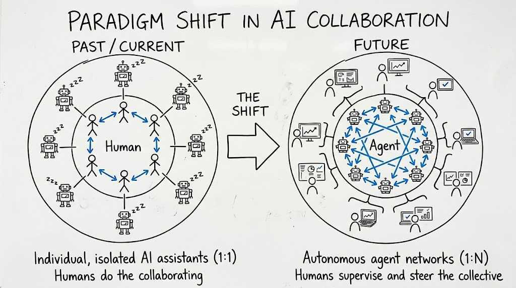
• The leadership shift from pet agents to agent teams that collaborate at speed
be sure to share it with them.
AI Agents Make Better Decisions When They Know Where
AI agents are getting sharper at text, images, and internal company context, yet they still stumble when decisions depend on the physical world. The key gap is grounding: giving an AI system a reliable, up to date understanding of where things are and what is true right now. Location intelligence and geospatial data turn “smart” answers into usable answers by connecting reasoning to streets, addresses, roads, traffic, closures, elevation, and points of interest. Without that grounding layer, an agent can sound confident while recommending a pedestrianized road for an EV charging station or treating two nearby roads as connected when one is a bridge and the other is a tunnel. For enterprises, that kind of mistake is not a small error, it is operational risk.
A major challenge is that the world changes faster than model retraining cycles. Large language models typically learn from snapshots, but reality updates by the minute: traffic patterns shift every second, roadworks appear, turn restrictions change, restaurants close, and new routes emerge. That is why modern enterprise AI needs both a structured representation of the world and a way to validate facts at query time. Vector embeddings and vectorization help translate location data into formats AI agents can use for retrieval and reasoning, while real time validation helps an agent confirm whether a street is accessible, whether a closure is active, or whether a business still exists before producing a recommendation. This combination reduces hallucinations, increases trust, and makes agentic workflows safer.
The business value becomes obvious in high stakes use cases like insurance. Claim validation can improve when an agent can check whether a reported left turn was forbidden on a specific date and time, or whether traffic conditions make a story plausible. Risk pricing improves when insurers move from coarse zip code scoring to address level underwriting using distance to water, elevation, proximity to forest, and other geospatial risk indicators. That shift can create fairer premiums for customers while improving loss ratios for insurers, and it does not require every team to hire a GIS specialist. The promise of AI plus location intelligence is that non experts can access powerful geospatial analytics through agent tools that handle the complexity behind the scenes.

Joeri Billast and Leo Sei, TomTom, at the Web Summit podcast booth
Keeping location intelligence fresh requires an ecosystem, not a single dataset. Base maps benefit from open collaboration, while higher frequency updates come from many signals: automotive sensors processed on device, municipal schedules for planned works, feedback loops from fleet and mobility partners, and aggregated mobility patterns that reveal new roads or persistent closures. At the product layer, developers need simple access through APIs and SDKs, while AI systems increasingly need agent friendly interfaces like tool calling, MCP style integrations, and embedding ready datasets. When these pieces come together, location intelligence becomes an “eyes and ears” layer for enterprise AI across logistics, fleet management, warehouse and site selection, emergency services dispatch, urban planning, and smart city operations. As organizations evolve, the winners will be the ones who design agent ready data pipelines, clear governance, and workflows where humans supervise outcomes while agents coordinate the work.
Related Posts:






Want to see more of my articles in Google? Add webdrie.net as a preferred source.